An RV Atlas for All 63 Parks — Worth Throwing in the Cab?
I reviewed Majosta's all-63-parks RV atlas so you don't have to piece together campground and dump station info from a dozen tabs. Solid planning tool with a few honest caveats.
Disclosure: This site is reader-supported. When you buy through links on this page we may earn an affiliate commission, at no additional cost to you. This does not influence our editorial recommendations.
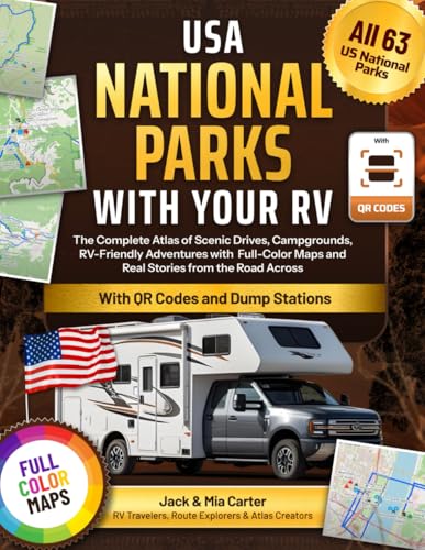
I was sitting in my 4Runner, parked at the edge of a campground loop in the Smokies, watching an RV driver do a fourteen-point turn into a site that was clearly two feet too short for his rig. It was painful. Honestly, it was the kind of scene that makes you wonder how many people hit the road without doing even basic homework on clearances, hookups, or dump station locations. That moment stuck with me when I came across the Majosta atlas USA National Parks with Your RV, a full-color, all-63-parks reference built specifically for RV travelers who want practical information before they pull out of the driveway.
We may earn from qualifying purchases.
First impressions
The title alone is doing a lot of heavy lifting, campgrounds, dump stations, full-color maps, and "real stories from the road" across every single national park. That's an ambitious scope. When I first flipped through it, my honest reaction was that the production values look solid for a travel atlas in this category. The full-color maps are the main draw, and for good reason: knowing which campground loops can handle a 35-foot rig versus which ones top out at 25 feet is the kind of detail that saves you from becoming that guy doing the fourteen-point turn.
What I appreciate is the organizational logic. Having dump station locations built into the same reference as campground guides means you're not juggling three different apps and a paper map while your copilot reads you turn-by-turn directions off a phone screen. For anyone who's done a multi-park swing through the Southwest, you know how fast that situation gets chaotic. A single consolidated resource has real value on longer trips.
The "real stories from the road" angle is a nice touch, though I'll temper that, I've read a lot of these atlas-style books where the narrative sections feel padded. Whether this one earns those pages is something each reader will decide, but for the logistics-first crowd, the maps and campground data are the reason to pick it up.
How it stacks up
I've hit 47 of the 63 parks, most of them in my 4Runner rather than an RV, but I spend a lot of time talking to RV travelers at trailheads and campground check-in lines. The consistent complaint I hear is that general travel guides don't account for RV-specific constraints, length limits, low-clearance roads, generator hours, dump station distances from camp. Most popular park guidebooks treat those as afterthoughts, if they mention them at all.
An atlas that bakes those details in from the start is a different kind of tool. Compared to piecing information together from individual park websites, the Recreation.gov app, and various RV forums at eleven o'clock the night before you leave, having it in one place matters. You can grab a copy here and spend an evening actually planning your route instead of browser-tab hunting.
Coverage across all 63 parks is genuinely useful for trip chaining. If you're routing from Great Basin to Capitol Reef to Canyonlands, you want consistent formatting park to park so you're not re-learning the layout each time you flip to a new section. That kind of structural consistency is where a dedicated atlas beats a patchwork of blog posts.
I'll also say this: the physical format matters more than people give it credit for. A book sits open on the passenger seat or the dinette table. It doesn't need a signal, doesn't drain a battery, and doesn't lock up when you're in a canyon with no cell service. For RV travel specifically, where you're sometimes stationary for days in remote locations, that's not a minor point.
Honest gripes
Here's where I'll be straight with you. Because Amazon's listing doesn't surface specific details, page count, publication date, update cycle, I genuinely can't tell you how current the campground data is. That's my biggest concern with any print atlas covering national parks right now. Fee structures change. Sites get added or closed after fire damage or infrastructure work. A book that was accurate when it went to press can have outdated information within a year or two, and that matters when you're counting on a dump station being where the map says it is.
My other gripe is the "real stories" framing. In my experience, that kind of content can read as filler that pushes the practical charts and maps further back in each section. If I'm budgeting space in my cab for a reference book, I want the useful stuff up front, not buried after three pages of someone's sunrise moment at Glacier. That's a stylistic preference, not a dealbreaker, but it's worth knowing your own reading priorities before you buy.
Pricing wasn't available through the listing at time of writing, so check the current price on Amazon before you decide. And if you're someone who relies heavily on current crowd-sourcing for campground conditions, pair this with a live app, don't treat any print atlas as a sole source of truth for time-sensitive logistics.
| Pros | Cons |
|---|---|
| Covers all 63 national parks in one reference | Print date and data currency aren't clear from the listing |
| Full-color maps built for RV-specific needs | Narrative "stories" sections may slow access to practical data |
| Dump station locations integrated with campground info | No pricing visible at time of writing, confirm before buying |
| Works without cell signal | Can't replace real-time condition updates from apps or ranger stations |
| Single consistent format park to park makes trip chaining easier | RV length and clearance specs should be verified against current park info |
Honestly, if you're planning a serious multi-park RV trip and you're still trying to cobble together logistics from a dozen different sources, a dedicated atlas is a smart addition to your prep stack. It won't replace your park-specific research, but it gives you a solid skeleton to build from. The 47 parks I've managed in my 4Runner have taught me that good trip planning is mostly about knowing what you don't know, and a resource like this helps you ask the right questions before you leave home. Drive smart, pick your sites early, and for the love of everything, check your clearances before you commit to a campground loop., Marcus
Frequently asked questions
- Does this RV atlas cover all 63 US national parks?
- Yes, based on the title it covers all 63 national parks, which makes it useful for multi-park trip planning without having to switch between different references for each destination.
- Does the book include dump station locations?
- The listing specifically calls out dump stations as part of the content, which is one of the more practical features for full-time or long-haul RV travelers who need that information integrated with campground maps.
- Is a print RV atlas still useful when apps like Recreation.gov exist?
- Honestly, yes — especially in areas with poor cell service. A physical atlas works without signal, doesn't drain your phone battery, and gives you a consistent layout across all parks in one place. I'd use it alongside an app, not instead of one.
- How current is the campground and fee information in this atlas?
- That's the one thing I'd be cautious about with any print atlas. Publication date and update cycle weren't clear from the listing, so verify site availability, fees, and access roads against current park websites before you finalize your plans.
- Is this book useful for tent campers or is it strictly for RV owners?
- The focus is clearly RV travel — campground hookups, dump stations, RV-specific routing — so tent campers would get less value from it. There are better general park guidebooks geared toward backpackers and car campers.